Sunday, June 13, 2010

Crater Lake NP, Oregon

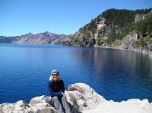
Crater Lake is the deepest lake in the United States at a depth of 1,943 feet. People are drawn to the intense blue color that changes as the sun moves across the sky. One can drive or bike around the lake along the road, hike up to see the lake from above, or take a boat ride to Wizard Island. The park road is only open about three months (late June/early July into September). The area has an average snowfall of about 40 feet! You can enjoy the scenery in the winter by cross-country skis and snowshoes.

To take the boat ride around the lake and to Wizard Island, you have to walk down to the lake's edge. It is interesting to hike below the rim into a volcano!

The main campground for the park is a few miles away from the lake. It is in a wooded area. It opens when all the snow melts. We were there over Labor Day weekend and had to break a thin sheet of ice off the tent in the morning. It can be cold! There is a historic lodge right next to the lake. Make reservations months in advance.

There are a few hikes in the area. One is to the Watchman Overlook with views of Wizard Island and the lake. The Pacific Crest Trail (PCT) also goes through the park. This is a great trail for backpacking.
There are also interesting rock formations called the Pinnacles. They remind me of the hoodoos of Bryce Canyon.
For more National Park information on Crater Lake, go the the NPS website.

Monday, May 31, 2010

Capitol Reef NP, Utah

Welcome to Capitol Reef! This rock formation is prominent in lots of postcards and pictures of the area. It is known as the Castle and you can see it from the visitor's center.

The park has many geology features (a monocline, the Waterpocket Fold) as well as history. Historic Fruita has turn-of-the-20th-century buildings that you can visit via roads and footpaths. Don't forget to stop at the store and buy jams and jellies made from the local fruit orchards. You can pick many of the fruits yourself. Here is the schedule of fruit harvest times.


To experience the geology, there is a 10 mile paved scenic drive as well as some unpaved, dirt road spurs (make sure you have the correct vehicle and that the weather is fair). Along the scenic drive you can get out of the car and do some hiking. Here is Grand Wash (you can see my sister as a little white dot in the lower right hand part of the wash). This perspective shows you how high the canyon walls rise above the wash.

Another hike we recommend is the trail to Hickman Bridge. There is a nature trail that explains plants and animals of the area as you hike the 1 mile to the bridge. Legend has it that Capitol Reef was named for a line of white Navajo Sandstone domes that look like the United States Capitol dome. Here is a picture of what I think is one of those domes.


This is one of the lesser known national parks that I would recommend visiting. It can be a bit hot in July and August for hiking. The campground is nicely shaded and has grass. For more information, here is the official national park site of Capitol Reef.

Sunday, November 2, 2008

Canyonlands NP, Utah


This is a vast area of canyons near Moab, UT. The park is divided into three sections: Island in the Sky, The Needles, and The Maze. Island in the Sky is the most visited area. It is a "smaller" version of the Grand Canyon in Arizona. A popular thing to do do in this area is mountain bike the White Rim Road. The White Rim Road reminds me of hiking down to the Tonto Plateau of the Grand Canyon----you are not quite at the bottom, but you are below the rim and can experience canyons below the rim.

One of the more popular views along the Island in the Sky road is Mesa Arch. In the distance are the snow-capped La Sal Mountains. We visited here in May and had enjoyable weather. Since this is desert, the best times to visit are spring and fall.

There are plenty of short hikes to do in the Island in the Sky unit. Two of them I did were the Upheaval Dome (interesting rock formations) and the popular Grand View Point trail. There are longer hikes as well as backpacking opportunities.

We did not camp in the park. We camped between the park and Moab. There is also another state park with the view to the left known as Dead Horse Point. In the late 1800s there were many wild mustangs in the area. Supposedly they were corralled at this point and "broken", but the ones that couldn't be were left with the gate open. These "broomtails" never left and died of thirst.

For more information on the other two units of Canyonlands, here is the link to the NPS site:
http://www.nps.gov/cany/index.htm

Sunday, October 12, 2008

Bryce Canyon NP, Utah

Hiking among the hoodoos is an amazing experience! When you first see the canyon, you look over the rim to see many pillars of rocks called hoodoos. The colors of the rocks change as the sun moves through the sky. I would recommend experiencing the overlooks at sunrise and sunset----the colors seem to be the most vibrant at these times.


Make time to go below the rim. The hoodoos are a lot taller than what you see on the rim. The most popular trails are the Navajo Loop trail and the Queens Garden trail. If you visit for a few days, there are longer trails: the Peekaboo Loop and if you want to backpack, there is the Under the Rim trail.

You can visit this canyon year round, but in the winter you may be using snowshoes or skis to explore the trails. In the summer, it is also quite cool in the evenings. Since the rim of Bryce Canyon is almost at 8000 feet, make sure you have an extra blanket when you are tent camping.

So plan your trip by visiting the NPS site for Bryce Canyon and go to the place that Ebenezer Bryce homesteaded and has been known to say "It's a hell of a place to lose a cow."

Monday, September 15, 2008

Black Canyon of the Gunnison NP, Colorado


For a few years I looked on the map and wondered what the Black Canyon of the Gunnison in western Colorado was all about. Finally one Memorial Day a few years ago my sister and I met my friend there to check it out. As you see from the picture above, it is a canyon that you just come upon after driving through the green fields.

The south rim campground was quiet and nice considering it was Memorial Day weekend. The hiking on the south side of the canyon is limited-----only one steep trail does go down to the river. There are a few hikes right below the rim----and a nice rim drive with many turn-offs.


If you want you can drive down to the river by a VERY steep road. At the river there is another campground and a lot of fishing opportunities----and this is where the dams start that create reservoirs that are a part of the Curucanti National Recreation Area. We went on a boat ride in this higher part of the canyon.
For more information (including north side of the rim and backcountry parts) from the National Park Service: Black Canyon of the Gunnison NP

Tuesday, June 17, 2008

Badlands NP, South Dakota


This is the park that you stop at between Wall Drug and Mount Rushmore. I stopped here in the middle of July----so hiking is not what you want to do when it is 112 degrees F. In the middle of the day there was no silence---just that sound of wind. But the wind made the grass move in waves. I think that the wind and the waving grass helped soften the harshness of the landscape and the heat. A rabbit even hopped through the grass as I sat on the boardwalk.

Looking at the rest of the park, there is a moonscape look about it----lines of color---mounds of earth in many shapes. I read about some short hikes that you can do----or you can go back country with map and compass.

There is an inn right outside of the park---I listened to cows mooing and waited for the stars to come out.

To find out more about the park and surrounding area, here is the National Park Service Badlands NP website.

Wednesday, June 4, 2008

Arches NP, Utah


It is a rainy evening, so instead of hiking I will add my next park I have visited, Arches National Park. I even get to drive around with the Delicate Arch on my license plate. Ironically, I have only visited the park two times----first time in 1991 and the last time in 1998.

The first time was in the beginning of July. This is not the time to come to enjoy hiking unless you like 100F temperatures. We hiked early in the morning to arches in the Devils Garden area in the north end of the park. This is the Landscape Arch in two views----from in front----and from underneath.

This is the park of arches---in fact 2000 cataloged arches. The most famous is the Delicate Arch, but since it was so hot and we were camping in the north end of the park, we never hiked to it. I would highly recommend hiking to it----you may have seen it during the 2002 Olympics----the torch stopped there.

Another hike we did at sunset (after the first hike, we spent the mid-day at the air-conditioned Moab library) was the hike to the Windows. Sunset in the desert treats you to many colors---and silence.

We enjoyed the campground. The sites are separated by rocks. The only thing lacking is shade.

My second time to the park was another quick trip with an out-of-town guest. That time was spent on the south end of the park in the Park Avenue area.

For more information on the park, I would visit the Arches NPS site.